
![]()
![]()
![]()
![]()
![]()
![]()
![]()
![]()
![]()
![]()
![]()
Research
![]()
![]()
![]()
![]()
![]()
![]()
Navigate
![]()
![]()
![]()
![]()
![]()
![]()
![]()
![]()
Tropospheric NO2 from GOME measurements
Introduction Data FAQ References Links Contact
 Introduction:
Nitrogen dioxide plays an important role in both troposphere and
stratosphere. It is involved in catalytic ozone destruction and at the same time in
the “buffering” of ozone destroying halogen oxides into more stable reservoir
substances. In the troposphere, NO2
is one of the key players in the formation of photochemical smog during pollution
episodes. Locally, it may also contribute to
radiative forcing.
From GOME measurements, NO2 columns can be retrieved in the
425-450 nm region. NO2 columns are part of the GOME lv2-products provided by DLR, but at the IUP Bremen an
offline scientific NO2 product is created. The GOME measurements contain both tropospheric and stratospheric
contributions, and a separation algorithm has to be used if tropospheric columns are the quantity of interest. In the case of NO2,
the most simple method is to use the Pacific sector as a clean background value and to assume that stratospheric NO2 is
zonally homogeneous. The difference between the actual measurement and the reference sector interpreted as tropospheric excess.
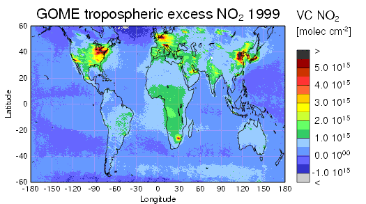
As an example, the plot shows tropospheric excess NO2 from GOME
for 1999. In addition to a general offset over the continents, strongly enhanced NO2 columns are detected over the
industrialised parts of the world and in regions of intense biomass burning. There also is some indication of NO2 from
lightning over Africa and for transport from the US, Asia and Africa to the Oceans.
Data:
Total columns of NO2 based on GOME Near Real Time data can be found on the GOME NRT page.
Monthly averaged tropospheric NO2 columns for the POET project can be downloaded here.
Stratospheric NO2 column data can be found on the QUILT page.
If you have any requests, please contact Andreas Richter.
FAQ:
- Why are there only individual stripes of data?
The stripes of data are the individual orbits of GOME measurements. There are 14 orbits per day, each of which has a swath width of 960 km. Together, they cover the globe within 3 days. Please note that it takes 35 days until the orbit pattern is repeated exactly (repeat cycle). Therefore, the measurements sample a given location on earth slightly differently over the course of a month which improves the spatial resolution in monthly averages over the resolution of an individual GOME measurement. Why are the satellite swaths sometimes so much smaller?
On some days (the 5th, the 10th, and the 25th of a month) GOME is operated in a special "narrow swath" mode. In this mode, the spatial resolution is improved to 80 x 40 km2 but the spatial coverage is reduced as result of the smaller swath (240 km instead of 960 km).Why are there sometimes two orbits close to each other around 150° longitude while on other days there is a wider gap between orbits?
The daily maps produced here are based on all orbits with their first measurement on the day of interest, where time is UT. However, the UT date change occurs somewhere in the middle of one of the orbits close to 150° longitude, and depending on where this change happens, one orbit more or less will be displayed for a given day. In those cases where two orbits are close to each other, the difference in time is nearly 24 hours which often can be seen as a mismatch of flow patterns.Why are so many pixels missing?
Most of the gaps in the time series are either times when the instrument or the complete satellite was down or cloudy scenes which were removed from the tropospheric columns.Why are there negative values in the tropospheric columns?
The quantity plotted is the tropospheric excess column of NO2, which is the surplus of NO2 as compared to a clean region. Therefore, the background of tropospheric NO2 is missing in the data, which is introducing a negative offset. In addition, the analysis is based on the assumption that the stratospheric NO2 field variation is correctly reproduced by the SLIMCAT model, and errors are introduced if this does not hold (for example in spring or close to the polar vortex).What is the spatial resolution of GOME?
The spatial resolution of GOME is 320 x 40 km2 in standard mode and 80 x 40 km2 for the narrow swath measurements (see above).
References:
- Richter, A., Burrows, J. P., Nüß, H., Granier, C, Niemeier, U., Increase in tropospheric nitrogen dioxide over China observed from space, Nature, 437, 129-132, doi: 10.1038/nature04092, 2005
- I. B. Konovalov, M. Beekmann, R. Vautard, J. P. Burrows, A. Richter, H. Nüß, N. Elansky , Comparison and evaluation of modelled and GOME measurement derived tropospheric NO2 columns over Western and Eastern Europe, Atmos. Chem. Phys., 5, 169-190, 2005
- D. Schaub, A. K. Weiss, J. W. Kaiser, A. Petritoli, A. Richter, B. Buchmann, J. P. Burrows, A transboundary transport episode of nitrogen dioxide as observed from GOME and its impact in the Alpine region, Atmos. Chem. Phys., 5, 23–37, 2005
- A. Petritoli, P. Bonasoni, G. Giovanelli, F. Ravegnani, I. Kostadinov, D. Bortoli, A. Weiss, D. Schaub,A. Richter, and F. Fortezza, First Comparison Between ground-based and Sattelite-borne Measurements of Tropospheric Nitrogen Dioxide in the Po Basin, J. Geophys. Res., 109, D15307, doi:10.1029/2004JD004547, 2004
- N. H. Savage, K. S. Law, J. A., Pyle, A. Richter, H. Nüß, J. P. Burrows, Using GOME NO2 satellite data to examine regional differences in TOMCAT model performance, Atmos. Chem. Phys., 4, 1895-1912, 2004
- T. Kunhikrishnan, M. G. Lawrence, R. von Kuhlmann, A. Richter, A. Ladstätter-Weißenmayer, and J. P. Burrows, Semiannual NO2 plumes during the monsoon transition periods over the central Indian Ocean, GRL, 31, L08110, doi:10.1029/2003GL019269, 2004
- Ladstätter-Weißenmayer, A., J. Heland, R. Kormann, R. v. Kuhlmann, M. G. Lawrence, J. Meyer-Arnek, A. Richter, F. Wittrock, H. Ziereis, and J. P. Burrows, Transport and build-up of tropospheric trace gases during the MINOS campaign: Comparision of GOME, in situ aircraft measurements and MATCH-MPIC-data, Atmos. Chem. Phys., 3, 1887–1902, 2003
- Stohl, A., H. Huntrieser, A. Richter, S. Beirle, O. Cooper, S. Eckhardt, C. Forster, P. James, N. Spichtinger, M. Wenig, T. Wagner, J. Burrows, and U. Platt, Rapid intercontinental air pollution transport associated with a meteorological bomb, Atmos. Chem. Phys., 3, 969-985, 2003
- Edwards, D. P., J.-F. Lamarque, J.-L, Attie, L. K. Emmons, A. Richter, J.-P. Cammas, J. C. Gille, G. L. Francis, M. N. Deeter, J. Warner, D. C. Ziskin, L. V. Lyjak, J. R. Drummond, and J. P. Burrows, Tropospheric Ozone Over the Tropical Atlantic: A Satellite Perspective, JGR, 108(D8), 4237, doi:10.1029/2002JD002927, 2003
- A. Lauer, M. Dameris, A. Richter, and J. P. Burrows , Tropospheric NO2 columns: a comparison between model and retrieved data from GOME measurements, Atmos. Chem. Phys., 2, 67–78, 2002
- Heland, J., Schlager, H., Richter, A., Burrows, J. P., First comparison of tropospheric NO2 column densities retrieved from GOME measurements and in situ aircraft profile measurements, GRL, doi:10.1029/2002GL015528, 2002
-
Richter, A. and J.P. Burrows, Retrieval of Tropospheric NO2 from GOME Measurements, Adv. Space Res., 29(11) ,1673-1683, 2002
-
A. Lauer, M. Dameris, A. Richter, and J. P. Burrows , Tropospheric NO2 columns: a comparison between model and retrieved data from GOME measurements, Atmos. Chem. Phys., 2, 67–78, 2002
-
Velders, G. J. M.; C. Granier, R. W. Portmann, K. Pfeilsticker, M. Wenig, T. Wagner, U. Platt, A. Richter, and J. P. Burrows, Global tropospheric NO2 column distributions: Comparing 3-D model calculations with GOME measurements, JGR, D 106, 12643-12660, 2001.
-
Richter, A. and J.P. Burrows, A multi wavelength approach for the retrieval of tropospheric NO2 from GOME measurements, in proceedings of the ERS-ENVISAT symposium, Gothenburg October 2000, 2000.
Links:
- Have a look at the tropospheric SCIAMACHY NO2 columns that have a much better spatial resolution!.
- Tropospheric NO2 columns from GOME are also retrieved at the Institut für Umweltphysik, Universität Heidelberg.
- An assimilated tropospheric NO2 product based on GOME measurements is available as part of the GOA project at the KNMI.
- Recently, R. Martin from the Harward group has also done some work on tropospheric NO2 from GOME.
- More on the Global Ozone Monitoring Experiment (GOME) can be found on the University of Bremen GOME page, on the GOME page of DFD/DLR Oberpfaffenhofen, and at ESA/ESRIN.
Contact:
If you are interested in more information or GOME tropospheric NO2 data, please contact Andreas Richter.