
![]()
![]()
![]()
![]()
![]()
![]()
![]()
![]()
![]()
![]()
![]()
Research
![]()
![]()
![]()
![]()
![]()
![]()
Navigate
![]()
![]()
![]()
![]()
Airborne imaging DOAS measurements (iDOAS)
Introduction Instrument Observation Geometry Viewing Angles Imaging Quality First Results References Links Contact
 Introduction:
A new imaging DOAS (iDOAS) instrument has been developed at IUP Bremen in 2011.
The
instrument records scattered and reflected solar radiation in the visible
wavelength region. From the measurements, molecular absorption structures are
identified and analysed by applying the DOAS technique.
The iDOAS instrument is capable of measuring amounts and spatial
distributions of tropospheric trace gases, e.g., nitrogen dioxide, NO2.
This is useful for pollution mapping, identification of source regions and
source strengths, emission fluxes as well as satellite data validation.
Imaging DOAS
observations from an airborne platform have many advantages. Several viewing
directions are observed at the same time, i.e., a broad stripe below the
aircraft across track is imaged onto the instrument detector. iDOAS provides
good spatial resolution on the order of 100 m, at useful spatial coverage. In
general, aircraft observations form a link between ground-based
observations and satellite measurements.
There are two
major specialities about the iDOAS instrument. A frame transfer CCD detector is
used so that subsequent measurements are recorded without temporal gaps in
between. In addition, an optical light guide with sorted fibres is used which
allows flexible integration of the instrument in the aircraft.
First
test flights have been conducted during a flight campaign in June 2011 onboard
the AWI Bremerhaven aircraft Polar-5. The new iDOAS instrument performed well
and operated reliably. It proves to be a suitable device for the observation of
pollution sources and similar features. Further flight campaigns are foreseen
for the future.
 |
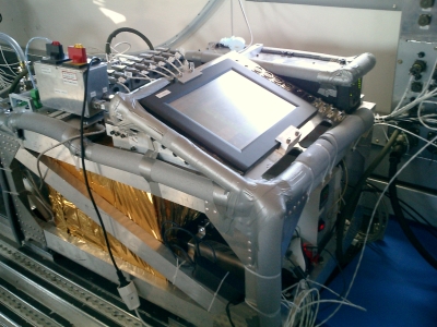 |
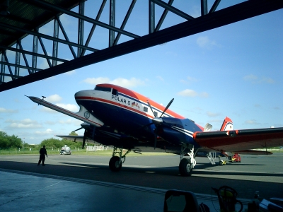
Figures: (Left) Polar-5 aircraft at the
hangar in Bremerhaven. (Right) iDOAS installed inside the Polar-5 aircraft in
Jun 2011.
Instrument Setup:
The special setup allows gap-free measurements (due to frame transfer CCD) and flexible positioning in aircraft (due to sorted fibre bundle).
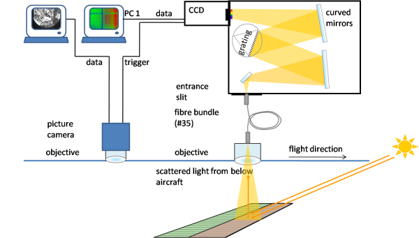
| Spectrometer type: | Czerny-Turner with 300 mm focal length |
| Spectral window/resolution: | 420 - 460nm / 0.7-1.0nm |
| Grating: | 600 l/mm |
| CCD Detector size: | 512x512 pixels, 8.2x8.2 mm² |
| Detector type: | Frame transfer (FT) technique |
| Entrance optics: | Wide angle objective + fibre bundle |
| Fibre bundle: | 35 sorted fibres imaged onto CCD |
| Power consumption: | < 550 W (variable, typically < 400 W) |
| Power Supply: |
230 VAC via UPS or 28 VDC via Inverter and UPS |
| Length x width x height: |
915 x 565 x
402 (given in mm; rack only!) |
| Mass | ~ 120 kg + ~ 10 kg base plate |
| Temperature of spectrometer |
35°C
(stabilized, spectrometer unit only) |
Observation Geometry:
|
|
 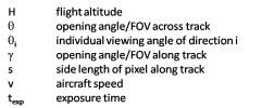 |
-
Field of view: ~48° across track (g), <3° along track (q)
-
Swath width: on the order of flight altitude H
-
Spectrometer viewing directions: max. 35 LOS (line of sight) from 35 fibres
-
LOS after averaging across track: fibres combined to e.g. 9 LOS (qi)
-
Exposure time texp: typ. 0.5s
-
Measurement sequence: no gaps between exposures
-
Spatial resolution: ~100 m (at H=1km flight altitude, 9 viewing directions)
-
The realized spatial resolution depends on flight altitude and required SNR
-
Two nadir ports are used: the spectrometer objective and a picture camera
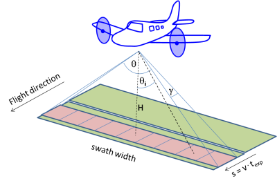
Viewing Angles:
Sketch showing the influence of the aircraft angles (pitch, roll and yaw) on the ground geolocation
-
Calculation of correct ground geolocation from the field of view is important
-
Geolocation information of the aircraft is received from GPS sensor and gyrometer
-
Consideration of the aircraft angles (pitch, roll and yaw) is required in addition to GPS position
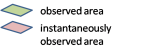
Influence of aircraft angles on geolocation:
-
Aircraft movement changes the ground pixel geolocation significantly. In addition, the magnitude of the displacement of the observed pixel on ground depends on flight altitude and LOS.
-
Displacements of the ground pixel at a flight altitude ~1km:
-
During straight tracks: on the order of a few tens of metres
-
During turns: typically on the order of 500 m, max. displacements larger than 1km
-
Average for central flight pattern on 04.06.11: around 160m
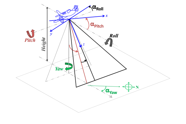
Imaging Quality
The imaging quality of the iDOAS instrument is very good and allows recording of small scale sources. In the figure above, the left figure shows the CCD intensity image (in absolute Counts). Spatial information is distributed along the vertical axis, spectral information along the horizontal axis. The stripes are generated by the individual fibres. The right image shows the photograph of the nadir picture camera above a brightly reflecting motorway in between darker fields to the sides. The blue box marks the field of view corresponding to the instant when the CCD image on the left was recorded. The high radiation intensity on the CCD image is nicely visible in one of the fibres only.
First Results: NO2 from Power Plant
During a flight on June 4th in 2011, a power plant exhaust
plume has been observed emerging from a black coal power plant. The recorded
spectra have been analysed for the absorption signal of NO2. The settings for
the DOAS retrieval are listed below. The enhanced NO2 amounts above the power
plant are clearly visible in the NO2 map. Large variations of the NO2 amounts
across and along track are observed
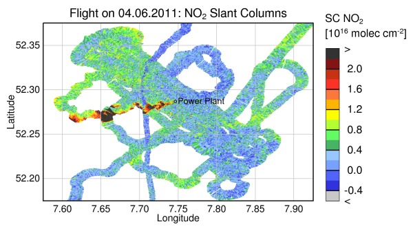
Figure: Preliminary result of NO2 slant columns above a black coal
power plant. The exhaust plume is clearly visible with enhanced NO2
amounts downwind of the power plant stack. From the slant columns, the vertical
columns and respective volume mixing ratios are computed by taking into account
the radiative transfer conditions as well as an NO2 altitude profile.
References:
- Schönhardt, A., Altube, P., Richter, A., Krautwurst, S., Gerilowski, K., Burrows, J.P., Aircraft measurements of anthropogenic NO2 with an imaging DOAS instrument, DPG Spring meeting, Berlin, Germany, March 2012
- Schönhardt, A., Richter, A., Krautwurst, S., Gerilowski, K., Wittrock, F., Burrows, J. P., A new airborne imaging DOAS instrument - development and first measurements, 5th International DOAS Workshop, Mainz, Germany, July 2011
- P. Altube Vázquez, Aircraft measurements of tropospheric NO2 with an imaging DOAS instrument, Master Thesis, University of Bremen, August 2012
- P. Wang, A. Richter, M. Bruns, J. P. Burrows, W. Junkermann, K.-P. Heue, T. Wagner, U. Platt, I. Pundt, Airborne multi-axis DOAS measurements of tropospheric SO2 plumes in the Po-valley, Italy, Atmos. Chem. Phys., 6, 329-338, 2006
- Wang, P., A. Richter, M. Bruns, V. V. Rozanov, J. P. Burrows, K.-P. Heue, T. Wagner, I. Pundt, U. Platt, Measurements of tropospheric NO2 with an airborne multi-axis DOAS instrument, Atmos. Chem. Phys., 5, 337-343, 2005
- M. Bruns: NO2 Profile Retrieval using Airborne Multiaxis Differential Optical Absorption Spectrometer (AMAXDOAS) data, PhD Thesis, University of Bremen, 2004
- Bruns, M., S. Bühler, J. P. Burrows, K.-P. Heue, U. Platt, I. Pundt, A. Richter, A. Rozanov, T. Wagner, P. Wang, Retrieval of Profile Information from Airborne Multi Axis UV/visible Skylight Absorption Measurements, Applied Optics, 43 (22), 4415-4426, 2004
Links:
- the iDOAS instrument has previously been operated in a different configuration as Airborne Multi Axis DOAS (AMAX-DOAS) instrument
- the iDOAS instrument was flown in tandem with the Methane Airborne Mapper MAMAP